
Now you can get detailed topographic maps that put trails, rivers, and campgrounds front and center without paying a dime.
The new 25K Recreational Topo Series is designed for people planning trips on foot, bike or boat and want reliable details that remain consistent from location to location.
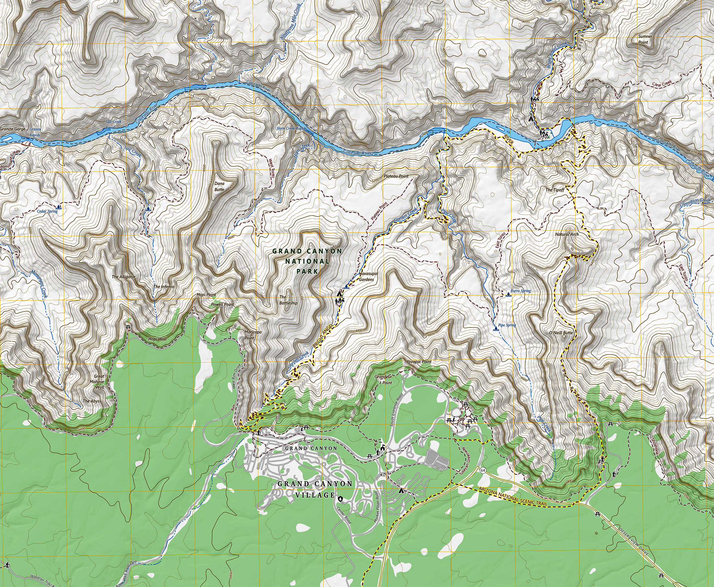
These maps emphasize actual navigation needs, from contour lines that show slope to symbols that point to trailheads and picnic areas. The layout is clean, the labels are readable and the information is up to date.
Recreational topographic maps
Ariel Doumbouya leads this effort as a geographer and product manager at the U.S. Geological Survey (USGS).
The goal is simple: to make official topographic information easier to read and apply in the field for everyday users.
“Whether you’re a seasoned explorer or a casual hiker, the new USGS maps are a game-changer for recreational activities,” Doumbouya said.
Recent release notes confirm that 25K Recreational Topo is now a selectable product, suitable for a 7.5 minute map extent and designed to highlight recreational datasets.
What the 1:25,000 scale means
The 25K Recreational Topo uses a scale of 1:25,000 and covers approximately 50 to 70 square miles per sheet. One inch on the map equals 25,000 inches on the ground, or about 2,083 feet, or about 0.4 miles.
This scale helps you gauge distance and effort with more confidence. You can compare route options that differ by a few hundred feet of climb or a short detour to the water without losing the big picture.
How to get topographic maps
Maps are created through topoBuilder, a public web application that allows you to center a map where you need it and upload a ready-to-use file.
The OnDemand Topo FAQ explains that these maps are generated for free using the best available data from The National Map.
You can choose the product, define the area and receive a digital file that works on a phone, tablet or desktop. There is no subscription and no special software is required.
What exactly are they?
A 25 km recreational topo shows the layers that are of most interest to hikers. Trails, surface waters, contours, boundaries, structures, travel routes and named places are symbolized for quick reading at arm’s length.
The design uses consistent legend and symbology across the country. This consistency reduces guesswork when moving from one park to another and still having to find a side trail or official campsite.
The maps are topographical maps, meaning they show elevation with contour lines and shaded relief. Tight contours mark steep slopes, while wider spacing indicates softer ground.
Security and accessibility
Each map is delivered as a geospatial PDF that preserves coordinates inside the file. The user guide explains how these files support navigation features in standard players and popular mobile applications.
Phones are convenient, but dense forest or steep canyons can reduce the positioning accuracy of built-in receivers.
A recent study measured smartphone GNSS performance under forest canopy and found that accuracy can drop compared to open sky conditions.
Cartographic literacy made simple
Clear styling prevents labels from cluttering important lines and symbols. This is important when you’re making a quick decision at a junction and need to spot the right segment of trail or see how quickly the slope is changing.
Major recreation icons mark trailheads, campgrounds, picnic areas and other amenities. Simple symbols, combined with readable names, help new users learn basic map reading skills.
Modern Data Connection
These maps are taken from The National Map, the federal repository that manages major layers such as elevation, hydrography, transportation, structures, boundaries and place names.
The advantage is speed and national coverage under one roof.
Because products are standardized, partners can improve specific layers and these improvements can translate into new downloads.
When a trail is changed or a footbridge appears, the update may be reflected in the next map you request.
Topographic maps and outdoor entertainment
The maps highlight public lands and protected areas, including national parks and national forests. This facilitates route and permit selection, and reduces the risk of accidental trespassing on private property.
Symbols for water sources, trail junctions and access points help improve pacing and planning. This is useful for families, first-timers, and seasoned teams who want to tailor their trip to weather, fitness, and weather.
The 25K Recreational Topo sits alongside other OnDemand Topo products, so you can change the scale for a broader view of an area or a closer view of a canyon.
The platform can expand as new datasets and mapping enhancements become available.
With free access, no barriers to connection, and files that work offline, this is public data serving the public good. This lowers the barriers for safe and informed exploration.
Click here to create and download USGS recreational topographic maps….
—–
Do you like what you read? Subscribe to our newsletter for engaging articles, exclusive content and the latest updates.
Check us out on EarthSnap, a free app brought to you by Eric Ralls and Earth.com.
—–