Santa Ana’s wind forecast for Southern California has deteriorated, with officials saying conditions will bring “a risk of significant fire spread” starting Monday.
The National Weather Service office in Oxnard issued the most extreme version of its fire weather warning on Sunday, known as a “particularly hazardous situation” alert.
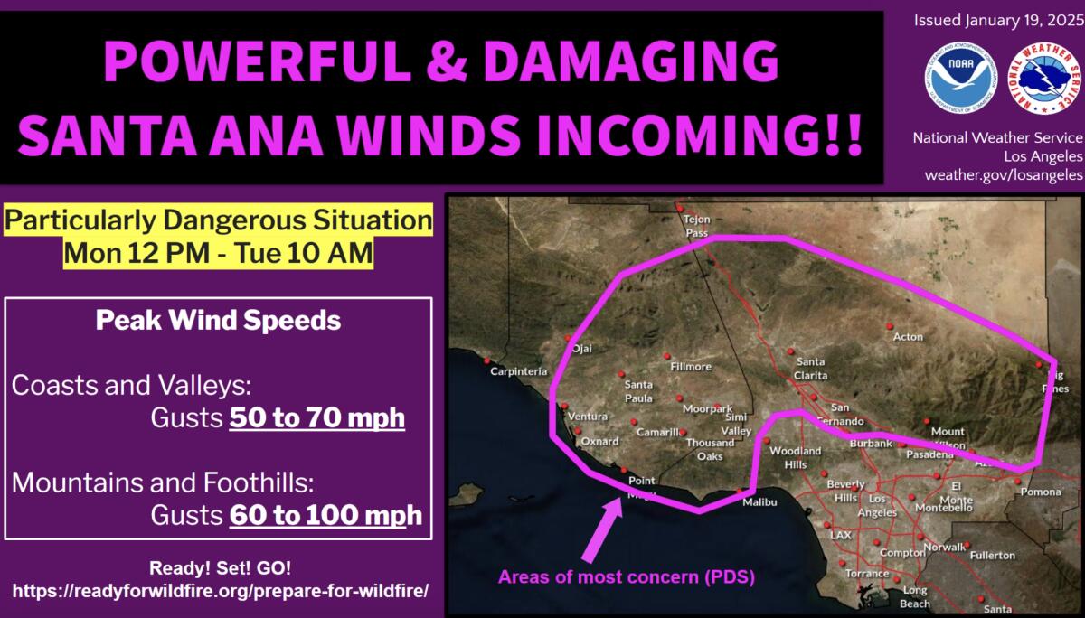
Much of Los Angeles and Ventura counties will likely be affected, including burned areas in Malibu and Altadena, weather service meteorologists said. They warned residents to prepare for the event, which is expected to begin at noon Monday and continue until 10 a.m. Tuesday.
Gusts of 50 to 70 mph are forecast for coasts and valleys. In the mountains and foothills, gusts of 60 to 80 mph, with isolated gusts of 100 mph, are expected.
“We encourage people to have that escape plan ready for you, your loved one, your pets – pack the essentials, pack that emergency bag just in case. Fuel cars and generators, secure outdoor items and adjust travel plans,” said Rose Schoenfeld, weather service meteorologist.
Besides Malibu and Altadena, the warning also includes Burbank, Santa Clarita, Oxnard, Thousand Oaks and Azusa. Both Ojai and Pasadena are outside the border, Schoenfeld said.

The National Weather Service issued its extreme version of a red flag warning for areas of Los Angeles and Ventura County on Sunday.
(National Weather Service)
A conventional red flag warning – indicating critical fire weather conditions and rapid fire spread with any new fires – is already in effect for large swaths of Los Angeles, San Diego, Orange, Riverside, San Bernardino and Ventura from 10 a.m. Monday to Monday. 10 p.m. Tuesday.
The new alert is the unprecedented fifth issuance of a “particularly hazardous situation” upgrade to a red flag warning in a single season by the weather service’s Oxnard office, which covers Los Angeles, Ventura, Santa Barbara and San Luis Obispo.
The first three “particularly dangerous situation” warnings were all followed by ignitions and rapid fire spread: the 19,904-acre Mountain Fire in Ventura County in November, which razed 243 structures ; the 4,037-acre Franklin Fire, which spread quickly to Malibu and destroyed 20 buildings in December; and this month’s Palisades and Eaton fires, among the most destructive and deadliest in modern California history.
The Oxnard Weather Service only began issuing “particularly hazardous situation” warnings in 2020. It issued two that year, in October and December. No more were issued until November 2024.
Over the weekend, firefighters battled the new threat of high winds to better contain wildfires still burning in Pacific Palisades and Altadena, areas under the red flag warning.
As of Sunday, the Palisades Fire, which has burned more than 23,700 acres and killed at least 10 people, was 52 percent contained, according to the state Department of Forestry and Fire Protection. The Eaton Fire, which charred more than 14,000 acres and killed at least 17 people, was 81 percent contained.
According to the Los Angeles County Sheriff’s Department, 27 people are still missing: 20 from the Eaton fire and seven from the Palisades.
More than 2,700 federal and state firefighters continued to battle the Eaton Fire on Sunday – slightly fewer than the day before as some fire crews were relieved of duty. Carlos Herrera, public information officer for the Los Angeles County Fire Department, said officials will continue to release firefighters – from across the country as well as Canada and Mexico – as the lockdown continues. intensifies.
But the department will remain in communication with weather experts to staff appropriately, “especially in Altadena, Mount Lowe and Mount Wilson — some places where we are looking at getting containment,” Herrera said. “We have a lot of resources.”
More than 5,600 firefighters remained attached to the Palisades Fire on Sunday, about the same number as the day before.
Melanie Miller, public information officer for the Palisades incident, said crews were doing “contingency planning” in anticipation of stronger wind and waiting to see if a change in action would be necessary or whether resources could be freed up.
Other areas affected by the warning include Santa Monica and the San Gabriel Valley. Areas outside the red flag warning zone include the Los Angeles basin, such as downtown Los Angeles, Torrance and Long Beach, as well as coastal San Diego and Orange counties.
Malibu resident Kristen King is preparing for what might come with the winds.
“I’m afraid we’re going to have a replay of what we saw a week ago, 10 days ago,” she said Sunday while shopping. “We know that once a fire starts, it is very difficult to put it out.”
His house near Point Dume survived the Woolsey Fire in 2018, when almost every other house on his street burned. But the Palisades fire destroyed the real estate agency where she works in Pacific Palisades. The new weather warning puts her on high alert.
“I can’t even sleep when they predict this because I think I have to be ready to jump in the car,” King said.
Michelle Harrison and her husband lost their home in an unincorporated area of Los Angeles County, just outside the Malibu city limits, when the Palisades Fire broke out on January 7.
Now, Harrison fears for those who could face even more threatening weather in Malibu this week.
“It’s just tragic,” she said. “I hope they have enough firefighters here, which I think they have now, to stop” any fires that might break out in the coming days.
Since this is more of a traditional Santa Ana wind event, with winds blowing from the east to northeast, Ventura County will be an area of great concern.

Red flag warnings, which indicate critical weather conditions and rapid spread if ignition occurs, are expected to be in effect across large areas of Los Angeles, San Diego, Orange, Riverside, San Bernardino and Ventura counties starting in Monday.
(National Weather Service)
In Los Angeles County, areas of greatest concern include the western San Fernando Valley, Calabasas, Agoura Hills, western San Gabriel Mountains and the Grapevine section of Interstate 5.

(National Weather Service)
Residents should secure loose outdoor items such as patio furniture; adjust travel times between Monday evening and Tuesday morning; recharge electronic devices, flashlights and batteries; filling emergency generator fuel tanks; and keep cars away from trees that appear fragile, Schoenfeld said.
Experts recommend against keeping certain items within 5 feet of your home, such as outdoor furniture, umbrellas, trash cans and recycling bins. Getting rid of any dead or living weeds in this area is also a good idea, as is cleaning gutters, roofs, decks, porches and stairs of flammable materials such as leaves and needles.
“And then, when the wind picks up, stay away from trees and windows. And be extremely careful, again, with anything that could start a fire,” Schoenfeld said.

(National Weather Service)
The gusts could be so powerful that they could overturn large vehicles and RVs and trigger power outages that could last several days, the weather service said.
Still, the risk of critical fire behavior is expected to be high with strong Santa Ana winds across much of the region, combined with extraordinarily dry air and parched vegetation, parched after eight months of virtually no rain.
Very dry conditions are expected all week, with Tuesday the driest, the weather service said. Relative humidity could drop as low as 5% in the western San Fernando Valley, Santa Clarita, Oxnard, Thousand Oaks and Fillmore.
Fire concerns will persist through the week, Schoenfeld said, with more Santa Ana winds possible by Thursday. The weather service could end the red flag warning Tuesday or extend it until Thursday.
Santa Ana winds are powerful winds that develop when high pressure over Nevada and Utah sends cold air toward areas of low pressure along the California coast. The wind season in Santa Ana generally runs from October to March.
The air dries, compresses and warms as it hits the mountains surrounding Southern California, and flows from the high deserts – of the Northeast – over the mountains of California and through the canyons, drying out the vegetation when the wind blows.
There is a chance of rain in about a week. But, at this point, it doesn’t seem like that’s the kind of drenching that would be needed to end the fire season, Schoenfeld said.
There’s about a 50 to 70 percent chance of rain Jan. 25-27, Schoenfeld said, and a 20 to 30 percent chance of thunderstorms.
“It doesn’t look like a really soaking rain over much of the area,” Schoenfeld said. “Honestly, this is bad news for our upcoming fire season. »
Times staff writers Melody Gutierrez and Libor Jany contributed to this report.
