
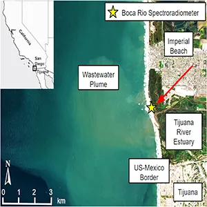
NASA’s imaging spectrometer aboard the International Space Station has spotted a plume of sewage flowing from the Tijuana River into the Pacific. The signal is strong enough that scientists can track pollution from orbit with just one color.
The plume is spreading along the South Bay coastline, where millions of gallons of sewage move into the river each year. The team focuses on a distinct drop in reflected light near 620 nanometers, a simple marker that stands out.
Plume of sewage seen from space
In a peer-reviewed study, researchers compared what EMIT, a NASA imaging spectrometer that helps identify materials on Earth’s surface, saw from space with spectra measured in the laboratory and in the estuary.
The 620 nanometer characteristic increased as the concentration of wastewater increased, with several water quality measurements showing very close correlations, achieving an R2 of at least 0.97.
The work was led by Eva Scrivner of the University of Connecticut (UCONN). His group traced the sewage signal from the river mouth to coastal waters and showed how to map its shape without sampling every location.
How the instrument detects waste water
EMIT relies on imaging spectroscopy, a technique that captures hundreds of narrow colors at a time. NASA’s instrument measures light in visible and infrared wavelengths to reveal the materials present.
The sensor records each scene with a resolution of approximately 60 meters, providing wide coverage and fine details. This combination allows you to see the trajectory of the plume in the water where boats and waders cannot go safely.
One candidate for the 620-nanometer plunge is phycocyanin, a pigment in cyanobacteria that absorbs orange-red light, which often rises in nutrient-rich water. This possibility is part of decades of research in remote sensing.
The team has not yet identified the exact source. Another possibility is dissolved organic matter chromophore, dissolved brown molecules that absorb blue light, which can vary depending on the wastewater.
From the bench to the coast
In the lab, the group mixed seawater with varying amounts of untreated sewage and measured a reflectance of 350 to 2,500 nanometers.
In the field, they compared these models to spectra from a land-based instrument and to EMIT scenes taken as the plume moved south past the river mouth.
NASA highlighted these results, noting that the satellite measurements closely matched field data and confirmed that EMIT could reliably detect coastal contamination from orbit.
Why it helps health agencies
Warnings about beach water safety are generally based on random samples and fixed probes. These tools are vital, but they leave gaps when contamination evolves quickly after storms or changing outfalls.
Satellite maps can direct samplers to the most affected areas on a given day. The 620-nanometer feature also tracks Enterococcus, a fecal bacteria used as a health indicator, which helps agencies decide where to test.
The method does not replace laboratory tests. This is a quick screen that shows where conditions appear worst, so teams can choose the most informative sampling sites and avoid risky areas.
As repairs move forward under a binational agreement, including a plan to complete key projects by 2027, the agreement sets out how satellite maps could guide daily decisions. Seeing the scope of the plume helps test whether the fixes are working.
Mapping wastewater plumes
The EMIT spectra reveal a trough near 620 nanometers and a neighboring shoulder near 650 nanometers. The team used the height of the fluorescence line, an index measuring the red glow in the spectra, to track how this shoulder weakens with distance from the river mouth.
The pixels closest to the mouth show the deepest features. Further out, the feature flattens as seawater dilutes the plume, providing a clean way to delineate contamination.
The wider EMIT experience
EMIT was designed for dust mapping, but the same precision also revealed gas leaks, allowing scientists to trace plumes of methane and carbon dioxide back to their individual sources.
This story matters here. If an instrument can check air and water signals with the same level of care, local agencies can compare hazards using a single data stream.
The 620 nanometer signal could be a regional tracer linked to wastewater and co-existing pigments. Calibrating it for other coasts will require more field data, careful atmospheric correction, and testing over multiple seasons.
This approach nevertheless offers an immediate advantage. It shows where to sample today and how far sewage spread yesterday, which is often the missing piece for beach safety and cleanup teams.
The study is published in Total Environmental Science.
Image credits: NASA/NOAA/ScienceAdvances.
—–
Do you like what you read? Subscribe to our newsletter for engaging articles, exclusive content and the latest updates.
Check us out on EarthSnap, a free app brought to you by Eric Ralls and Earth.com.
—–